When you're standing at the trailhead with weather closing in and visibility dropping, that iconic orange map in your hands becomes far more valuable than any smartphone. Over 403 individual maps covering every corner of Great Britain, yet most outdoor enthusiasts still grab the same trusted sheet before heading into the hills. Ordnance Survey Explorer Maps have earned their legendary status through decades of reliability, and they're not slowing down.
As the national mapping authority for Great Britain, Ordnance Survey has perfected the art of translating complex terrain into readable, trustworthy maps. These aren't just pretty pieces of paper; they're navigation tools that have guided walkers, cyclists, horse riders, and adventurers through some of Britain's most challenging landscapes. The difference between a confident expedition and a frustrating one often comes down to having the right map in your pocket.
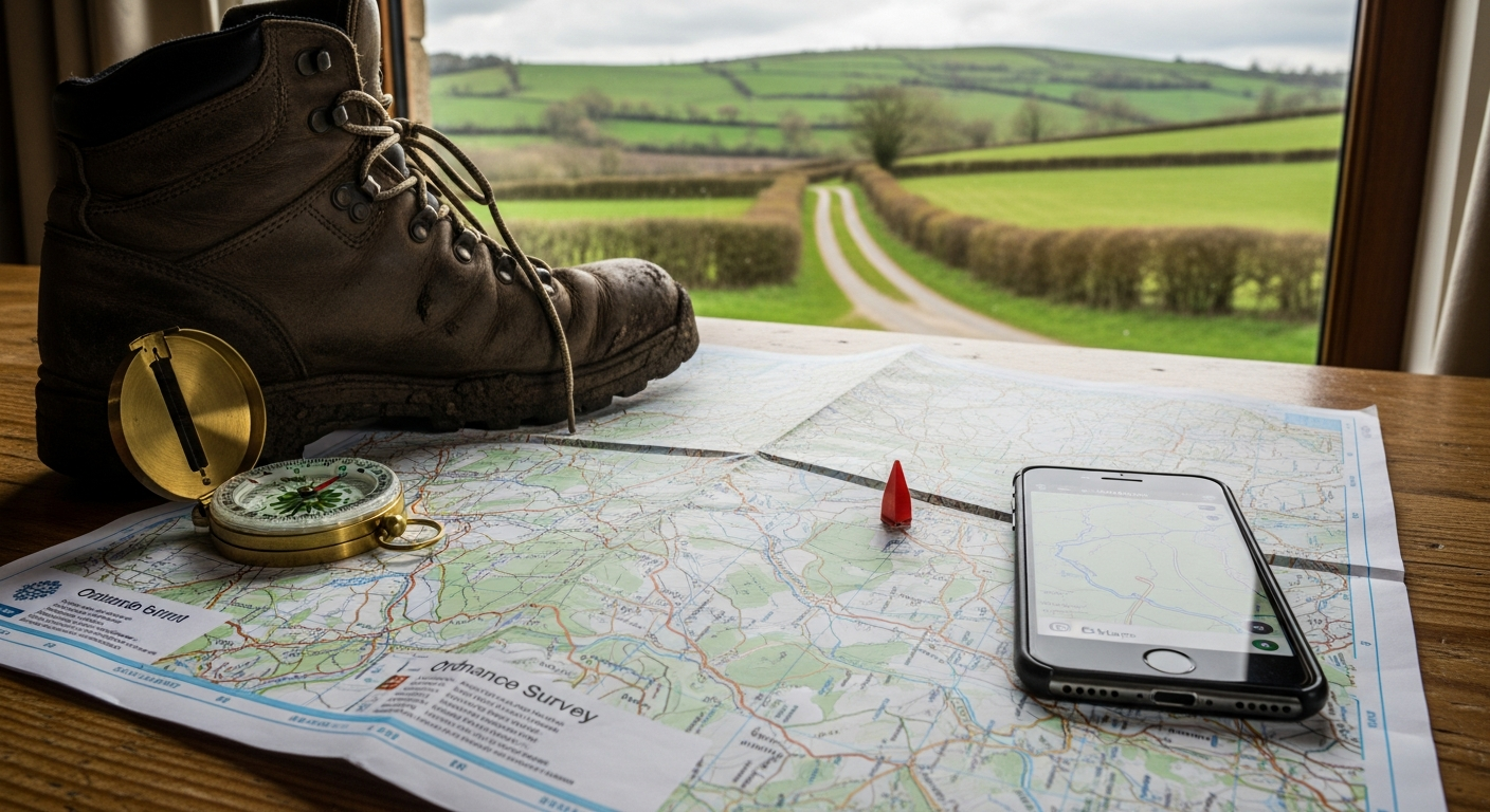
Discover why Ordnance Survey Explorer Maps remain the gold standard for outdoor navigation.
The 1:25,000 Scale Advantage: What Makes OS Explorer Maps Stand Apart
The defining feature of OS Explorer Maps is their exceptional clarity at 1:25,000 scale—where 4cm on the map represents 1km on the ground. This scale allows details to emerge that smaller-scale maps simply cannot convey. Footpaths and rights of way appear with precision, revealing networks of walking routes invisible on general reference maps. Bridleways receive dedicated marking, and open access land boundaries are clearly distinguished from private property.
Exceptional Detail Clarity
Footpaths and bridleways aren't merely suggested lines on OS Explorer Maps; they're rendered with enough precision to distinguish them from farm tracks and minor roads. This distinction becomes critical when planning routes through moorland or agricultural areas where unauthorized paths can lead to access disputes or dangerous terrain.
Terrain Elevation Intelligence
Contours are precisely marked throughout each map, providing the elevation data that transforms route planning from guesswork into informed decision-making. You can see exactly where gradients steepen, where valleys channel water flow, and which ridgelines offer gentler ascents. This information proves essential for calculating realistic timings and assessing whether your planned route matches your fitness level and equipment.
Vegetation and Landscape Nuance
Subtle changes in plant coverage and woodland boundaries receive clear distinction on OS Explorer Maps. Dense forest appears differently from scattered woodland, bracken-covered slopes contrast with grassland, and coniferous plantations stand apart from mixed deciduous forests. These distinctions matter considerably when navigating through unfamiliar terrain or predicting what conditions you'll encounter.
Practical Waypoint Identification
Campsites, pubs, and tourist information centers are marked throughout each map sheet, providing strategic reference points for route planning. Whether you're calculating midway refreshment stops or identifying emergency shelter locations, these marked facilities offer practical navigation anchors.
Paper vs. Active: Choosing Your Navigation Format
The choice between traditional paper and weatherproof Active versions represents your first strategic decision. Standard paper maps retail for £10.99–£13.00, with a recommended retail price around £12.99, making them accessible for building a comprehensive map collection. The more robust Active versions, laminated and specifically engineered for outdoor conditions, typically cost approximately double the price of their paper equivalents.
Traditional Paper Maps
Lightweight and affordable, paper Explorer Maps excel for planning expeditions and establishing broad area awareness. Their portability means you can carry multiple sheets without significant weight penalty. For day trips, weekend walks, and indoor route planning, paper maps deliver exceptional value. However, they require protective handling in wet conditions and susceptibility to damage from repeated folding limits their lifespan in demanding use.
Active Weatherproof Versions
The laminated Active versions withstand rain, repeated folding, and the general wear of multi-day expeditions. They're engineered for the punishment of serious outdoor adventuring—the kind where maps get stuffed into rucksacks, subjected to condensation, and retrieved in downpours. This durability comes at a cost, but for exposure-heavy terrain and extended treks, the investment protects your most critical navigation tool.
Durability Trade-offs
Paper maps demand careful storage and handling; they're vulnerable to water damage and permanent creasing from rough treatment. Active maps eliminate these concerns but represent a larger per-sheet investment. The practical decision often involves using paper maps for lower-risk day trips and building an Active collection for high-altitude adventures and multi-day expeditions.
Best-Use Scenarios
Paper maps shine for planning sessions, indoor route design, and shorter excursions where weather risk remains low. Active versions justify their premium cost on exposed terrain, winter climbing, coastal walks prone to sea spray, and any adventure where your map might experience serious environmental stress.
Start building your map collection with Ordnance Survey Explorer Maps today.
The Hybrid Navigation Revolution: Physical Maps Meet Digital Tools
The real innovation emerges when you recognize OS Explorer Maps as a gateway to hybrid navigation. Every physical map purchase unlocks a free digital download of the corresponding map area through the OS Maps app—an award-winning platform that transforms your smartphone or tablet into a sophisticated navigation instrument.
Free Digital Downloads Included
This bundled access represents exceptional value. You're not merely purchasing a paper map; you're accessing both tangible cartography and digital functionality. The corresponding digital file loads into the OS Maps app, enabling route planning, progress tracking, and offline navigation on your device.
Route Creation and Planning
The OS Maps app allows you to design custom trails directly on accurate Ordnance Survey cartography. Calculate distances, preview elevation profiles, and assess terrain difficulty before committing to an expedition. This planning capability transforms route selection from theoretical exercise into informed decision-making based on actual gradient data and terrain characteristics.
Offline Functionality
Downloaded maps function without cellular signal, protecting you from dead zones and battery drain from continuous data connections. You can navigate through rural areas, mountain regions, and remote terrain with complete confidence that your digital map remains accessible regardless of network coverage.
Real-Time Progress Tracking
During active navigation, the app monitors your location, calculates your pace, and displays elevation gain in real time. This information helps you assess whether you're maintaining schedule, identify navigational errors quickly, and adapt your route if conditions prove more challenging than anticipated.
Cost Analysis: Investment Tiers for Different Adventure Styles
Building a map collection requires strategic thinking about geography and budget. Individual OS Explorer maps retail between £10.99 and £13.00, with standard recommended retail pricing at £12.99. For those seeking comprehensive regional coverage, bundled sets start around £33.98 for smaller geographic areas.
Individual Map Pricing
Purchasing Explorer maps one at a time offers flexibility—you can build your collection gradually as your adventures expand geographically. Standard maps at approximately £13.00 represent reasonable investment for their cartographic quality and included digital access.
Active Weatherproof Premium
Expect approximately double the cost for laminated versions. A single Active map might cost £25–£26, requiring careful prioritization about which sheets justify the weatherproof investment based on your primary adventure destinations.
Regional Map Sets
Bundled collections deliver modest savings over individual purchases while ensuring comprehensive coverage of popular regions. These sets eliminate the piecemeal approach and provide coordinated cartography for multi-day expeditions spanning wider geographic areas.
Value Proposition
The free digital download bundled with every physical purchase fundamentally changes the economics. You're not just paying for paper or lamination; you're accessing a dual-format navigation solution that covers both planning and real-time tracking requirements.
Real-World Applications: Where OS Explorer Maps Excel
Different outdoor activities benefit distinctly from OS Explorer Map features. Each activity type leverages specific map elements that transform navigation from reactive problem-solving into proactive route management.
Walking and Hiking Expeditions
Detailed contours and precisely marked footpaths form the foundation of hiking route selection. You can identify which paths offer gentler gradients, assess cumulative elevation gain across your planned route, and distinguish established footpaths from unmarked terrain where navigation becomes significantly more challenging.
Cycling Adventures
Bridleway designations and road classifications guide cyclists toward appropriate routes. OS Explorer Maps distinguish between major roads, minor roads, and off-road cycling paths—information essential for planning bike-friendly expeditions that avoid heavy traffic while maximizing trail access.
Horse Riding Trails
Specific bridleway marking ensures riders can plan routes that comply with land rights and access regulations. Confusing bridleways with footpaths creates significant legal and practical problems; OS Explorer Maps eliminate this confusion through precise categorization.
Group Navigation
Physical maps facilitate collective route planning and broader area awareness. A group gathered around a paper map can discuss route options, identify potential hazards, and build shared understanding of the terrain ahead in ways that individual smartphone navigation cannot replicate.
Strengths That Keep Adventurers Coming Back
The enduring popularity of OS Explorer Maps reflects their genuine strengths across multiple navigation dimensions. These advantages compound over time, creating reliability that builds adventurer confidence.
Unparalleled Accuracy
Ordnance Survey's role as the national mapping authority for Great Britain guarantees trustworthy information. These maps represent decades of survey work, continuous refinement, and institutional commitment to accuracy. When you're relying on contour data to assess climbing difficulty or path information to verify you're on the correct route, this institutional reliability matters considerably.
Comprehensive Coverage
403 individual Explorer maps ensure virtually every British outdoor destination has dedicated cartography. Whether you're exploring Cornish coastal paths, Scottish highlands, Welsh mountain ranges, or English lake districts, corresponding maps exist specifically for those regions at the precise scale needed for effective navigation.
Tangible Reliability
Physical maps eliminate dependency on battery life, signal strength, or app crashes. Your paper Explorer Map functions perfectly after three weeks in a rucksack, survives accidental water immersion, and requires zero technical troubleshooting. This mechanical reliability represents significant reassurance when navigating exposed terrain.
Dual-Format Flexibility
Leverage paper maps for planning sessions and digital access for real-time tracking. The hybrid approach accommodates different navigation needs—detailed planning on a larger screen before departure and responsive tracking on your smartphone during the actual expedition.
Limitations Worth Considering Before Purchase
No navigation tool proves perfect for every situation. OS Explorer Maps carry genuine limitations worth understanding before building your collection.
Paper Map Vulnerability
Traditional versions remain susceptible to water damage and permanent creasing from rough treatment. Protective storage requires consideration; storing maps carelessly in damp conditions causes ink fading and paper degradation that reduces legibility. Maps subjected to repeated folding develop weak creases that eventually tear.
Active Version Cost Barrier
Weatherproof laminated maps cost significantly more than paper equivalents. Building comprehensive coverage of a large region requires substantial investment if you prioritize Active versions. Budget limitations often force difficult choices about which geographic areas receive weatherproof protection.
App Synchronization Issues
The OS Maps app, while generally well-received for its interface stability and route creation capabilities, has generated occasional criticism regarding syncing problems between digital and physical map data. Users occasionally report discrepancies in route information or access restrictions between the app version and printed maps.
Offline Access Constraints
Some users experience limitations when downloading maps for offline use. Advanced features such as route folders, waypoint management, and "snap to path" functionality remain limited, with "snap to path" currently restricted to National Parks. Power users seeking sophisticated route management may find the app lacking compared to specialized navigation software.
The Navigation Foundation You Can Count On
Ordnance Survey Explorer Maps have earned their position as Britain's most trusted outdoor navigation tools through relentless attention to detail, comprehensive coverage, and intelligent adaptation to modern adventuring needs. The 1:25,000 scale reveals terrain nuances that transform route planning from guesswork into informed decision-making. Whether you opt for traditional paper maps, invest in weatherproof Active versions, or leverage the hybrid approach combining physical cartography with digital tracking, you're accessing decades of cartographic excellence.
The real strength emerges when you recognize these maps as confidence builders that help you know exactly what to expect before stepping onto challenging terrain. For serious outdoor enthusiasts planning 2026 adventures, a carefully selected collection of OS Explorer Maps represents one of the smartest investments you can make, delivering tangible value across countless expeditions.
Get your essential Ordnance Survey Explorer Maps and navigate with complete confidence.
Leave a Reply